


VLH JOG 5km

thomarche
Gebruiker
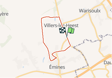

Lengte
5 km

Max. hoogte
196 m

Positief hoogteverschil
54 m
Km-Effort
5,7 km

Min. hoogte
166 m

Negatief hoogteverschil
55 m
Boucle
Ja
Datum van aanmaak :
2022-08-22 06:55:08.0
Laatste wijziging :
2022-08-22 07:31:45.872
36m
Moeilijkheid : Onbekend

Gratisgps-wandelapplicatie
 SityTrail
IGN / Geografische instituten
SityTrail Plus
De wereld gaat voor u open
Over ons
Tocht Lopen van 5 km beschikbaar op Wallonië, Namen, La Bruyère. Deze tocht wordt voorgesteld door thomarche.
Plaatsbepaling
Land:
Belgium
Regio :
Wallonië
Departement/Provincie :
Namen
Gemeente :
La Bruyère
Locatie:
Unknown
Vertrek:(Dec)
Vertrek:(UTM)
631017 ; 5598654 (31U) N.
Opmerkingen